Crossposted at Earth Alternatives
I'll go out on a limb here and ask you to recommend this diary, since it took 16 hours for me to research and format. I posted it earlier today and it was well-received, but it scrolled off the diary list fairly quickly and did not quite get the visibility I was hoping for.
I have scoured the MMS website for publicly available information about offshore drilling in the Gulf of Mexico, and what follows is the fruit of my labor, provided to you, dear Kossacks, as a public service. So without further ado, here we go...
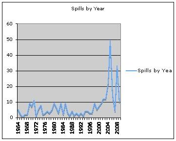
Note the spike in spills during Bush's presidency.
Links:
Central Gulf of Mexico Lease Sale Statistics- Bids Received by Water Depth:
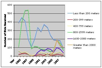
Not a single well deeper than 1600 meters was leased before 2001. I wonder if this is what Dick Cheney's Energy Task Force was planning behind closed doors.
Western Gulf of Mexico Lease Sale Statistics- Bids Received by Water Depth
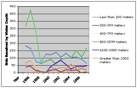
Ditto my former comment.
Crude Oil & Condensate Production: Graph of Offshore vs. All Other Domestic Production
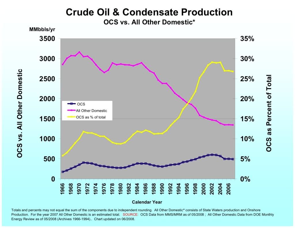
Conventional production is purple, offshore production is blue, and offshore production as a percentage of total production is yellow. As total production decreases, there is greater pressure to drill deeper offshore.
Gas Hydrates Offshore Louisiana
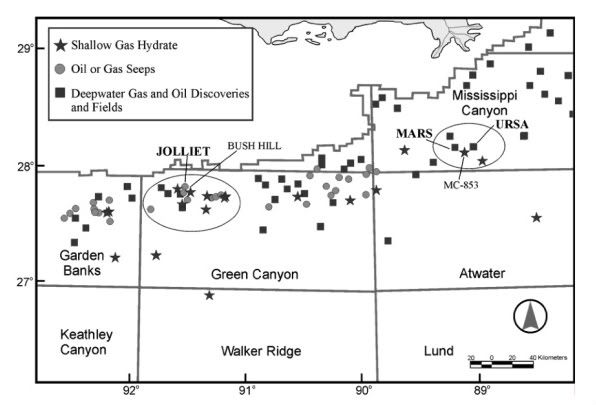
Note the hydrates in Mississippi Canyon, where the Deepwater Horizon exploded.
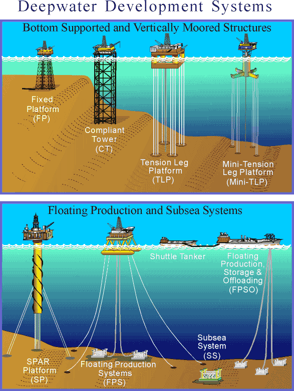
Deepwater Development Systems (Visual depiction of the different types of rigs and production platforms)
Blowouts & Loss of Well Control, 2006-2010
Exploration and Development Plans Database Search (Excellent resource if you want the details of a particular lease or company! FYI, a search by operator name for BP returns 768 results...)
Offshore Continental Shelf Regulations
Offshore Continental Shelf Civil and Criminal Penalties (This one is particularly upsetting– click on any year on the left hand side of the screen and you will see how these companies cut corners on a regular basis, creating dangers for rig workers and the environment.)
Deepwater Horizon Response: Official site of the Deepwater Horion Unified Command
Deepwater Natural Gas and Oil Discoveries and Fields (Good resource!)
Gulf of Mexico Permanent Deepwater Structures
Deepwater Production Summary by Year
GIS Data for Gulf of Mexico Gas and Oil Sands (ASCII Files)
MMS Deepwater News Releases and Additional Information
Useful PDF Resources:
BP Regional Oil Spill Response Plan (redacted- version 2; 598 pages, very heavy)
Current Deepwater Activity (There are currently 14 drilling operations deeper than BP's Mississippi Canyon failure. I have listed them below by depth.)
Petrobras America Inc. Chinook 8,850 ft. Shell Offshore Inc. Great White 7,814 ft. Anadarko Petroleum Corporation Callisto 7,790 ft. Shell Offshore Inc. Baha 7,790 ft. ATP Oil & Gas Corporation Aconcagua 6,997 ft. Kerr-McGee Oil & Gas Corporation Lucius 6,840 ft. Chevron U.S.A. Inc. Moccasin 6,750 ft. Statoil Gulf of Mexico LLC Tucker 6,667 ft. Noble Energy, Inc. Santa Cruz 6,500 ft. Marathon Oil Company Innsbruck 6,291 ft. Eni US Operating Co. Inc. Triton 5,380 ft. Shell Offshore Inc. Mensa 5,292 ft. Anadarko Petroleum Corporation Heidelberg 5,272 ft.
Deepwater Gulf of Mexico 2009: Interim Report of 2008 Highlights
Deepwater Gulf of Mexico 2008: American's Offshore Energy Future
Gulf of Mexico Oil and Gas Production Forecast: 2009-2018
Accidents Associated with Oil and Gas Operations, Outer Continental Shelf, 1956-1990
1964 (5) 1965 (2) 1966 (0) 1967 (2) 1968 (2) 1969 (9) 1970 (7) 1971 (11) 1972 (1) 1973 (5) 1974 (8) 1975 (2) 1976 (3) 1977 (4) 1978 (3) 1979 (5) 1980 (9) 1981 (6) 1982 (3) 1983 (9) 1984 (2) 1985 (9) 1986 (3) 1987 (1) 1988 (4) 1989 (1) 1990 (3) 1991 (1) 1992 (3) 1993 (1) 1994 (4) 1995 (4) 1996 (3) 1997 (3) 1998 (9) 1999 (5) 2000 (7) 2001 (9) 2002 (12) 2003 (12) 2004 (22) 2005 (49) 2006 (14) 2007 (4) 2008 (33) 2009 (10)
Of course, this diary would be incomplete without section 7.1 of BP's Initial Exploration Plan Mississippi Canyon Block 252 (Heavy PDF)
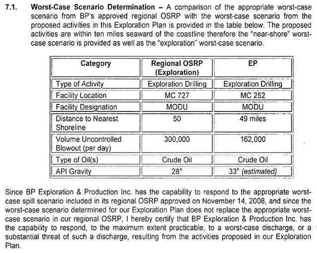
That's right, BP said it could handle a 162,000 barrel per day uncontrolled blowout. Based on what we've seen over the last four weeks, that statement is categorically false. If you want more information about the BP's Regional OSRP (Exploration) numbers above, you need look no further than here:
BP Regional Oil Spill Response Plan (Redeacted version 2; 598 pages, Very heavy PDF)
I'll be happy to add more links if they are submitted in the comments!
UPDATE #1:
h/t cadejo4:
NASA Terra and Aqua satellite images, usually up by mid-day or early afternoon. This are the ones that will most frequently show up in mainstream media.
European Union's Envisat images. These are frequently outstanding and rarely appear. You have to set the coordinates on the map and pick a range of dates. It's easy once you play around with it.
Florida's Oil Spill Academic Task Force, especially their animated projection of slick movement.
Roffer's Ocean Fishing Forecasting Service has a Deepwater Horizon page with a daily forecast. Also, really cool Quicktime movies of the gulf current, which looks like a sonogram of an artery when sped up.
LSU's Earthscan Laboratory. Not always up-to-date, but sometimes useful.
Sometimes you won't see anything obvious in the visual satellite images, but if you download them and adjust the levels a bit in an image processing program, the details can be enhanced substantially.
The Florida site has more really good resources, including some for ecological issues, such as an on-line book about dispersants.
UPDATE #2:
Thank you everyone for putting this at the top of the rec list! This community is great! I have to go get some shut-eye but look forward to reading all of your comments and discussion after I get a bit of rest.